Applications
Cosmogenic nuclides (10Be, 26Al and 36Cl) are an essential tool for establishing chronologies in many areas of the Earth Sciences, ranging from the active tectonics to the study of the past magnetic field through the climate fluctuations. Recently, their application has also been developed for the study of soil dynamics and the radioelement tracing with important issues for the nuclear industry. Cosmogenic nuclides produced in situ s allow to cover a range from 100 years to 6 Ma, which allows a quantification of surface processes over the whole Quaternary (deglaciations, seismic activity, soil development, evolution of hominids, etc.).
Access to the measurement of the concentrations of these elements is in particular a critical issue for research groups active in the field of natural hazards and the climate change. Indeed, from these concentrations, researchers can determine the ages of exposure of the rocks on the earth's surface and thus reconstruct their past history in relation to the following issues:
- compel theearthquake hazard from the age of morphological markers affected by an active fault
- compel the past climate fluctuations from the age of morphological markers (moraines, musty rocks) abandoned by the retreat of the glaciers.
The measurement of the concentrations of these cosmogenic nuclides in marine sediments or in polar ice can also be used to better constrain the chronologies of the Earth's and the Sun's geomagnetic fields, as well as to identify past volcanic eruptions.
The measurement of low concentrations of these elements in various types of natural samples (water, soil, ice, rock) requires very fine preparation techniques, followed by measurements of isotope ratios of up to 10-15and therefore inaccessible by classical analytical techniques, which implies the implementation of the Accelerator Mass Spectrometry (ADM).
Reconstructing past climates by dating glacier advance and retreat
Alpine glaciers respond significantly to climatic changes, in particular to temperature and precipitation. Establishing chronologies of their past extent allows us to better understand the climatic conditions on key palaeoclimatic periods such as the last deglaciation. In this study, the moraines of the Argentière Glacier, located in the Mont Blanc massif, were dated to 10Be, showing that the glacier had wider extensions and stagnated several times between ~11.7 and 10.4 ka, i.e. at the transition from the last ice age to the Holocene (the current warm period). Glacial modelling suggests that during this period the temperature was between 3.5°C and 5.5°C colder than today. This study also shows that at the end of the Little Ice Age (around 1820 and 1850), increased snowfall was responsible for an advance in 1820, while a cooling caused the glacier to advance in 1850.
Understanding past variations in the Earth's magnetic field
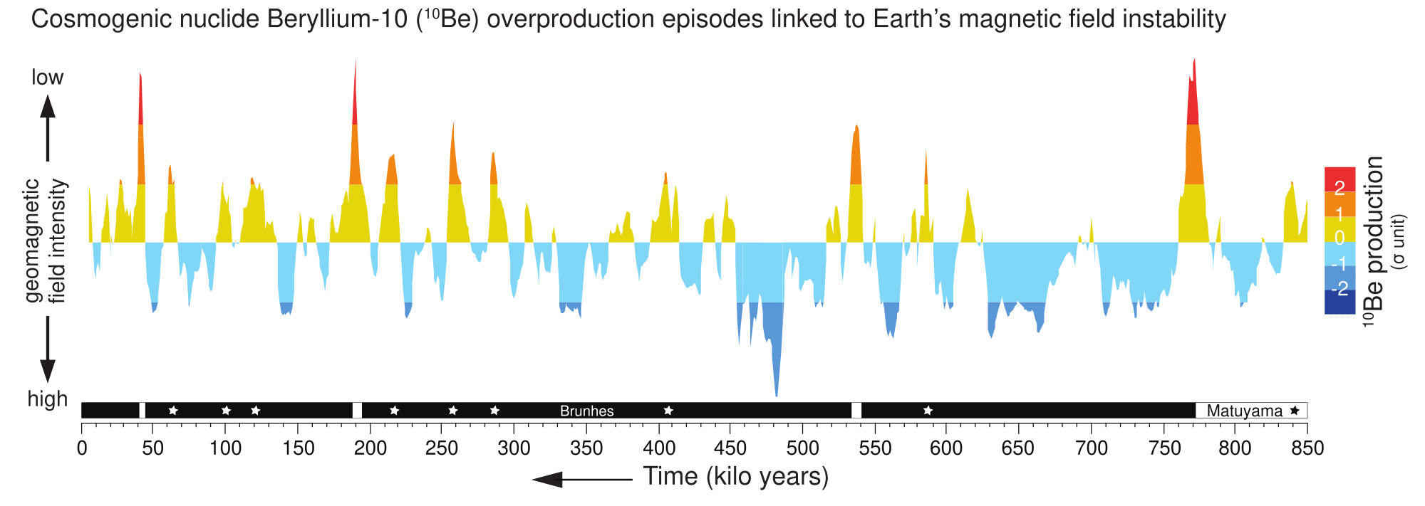
Past variations in the Earth's magnetic field are evidence of how the geodynamics work. The measurement of 10Be preserved in marine sedimentary sequences makes it possible to trace the fluctuations in the intensity of the field and, above all, to study the major crises in its evolution. Episodes of overproduction of 10Be have been highlighted in all the polarities reversals and geomagnetic excursions studied. These results allow us to quantify the dynamics of these transient episodes of field collapse. The rate of decay of the intensity preceding these episodes always appears to be lower than that measured over the last three centuries. This observation raises questions about the medium- or long-term persistence of the magnetospheric shield which protects the earth's surface from cosmic bombardment and maintains an intangible link with the biosphere.
Understanding the erosion of mountain ranges
The relief of mountain ranges, such as the Alps or the Himalayas, results from the combined influence of the tectonics and the climates. The respective importance of these two types of influence on the evolution of erosion in time and space is actively debated. The concentrations of 10Be in Himalayan river sands have enabled the erosion rates across the range to be determined. These data show a marked increase in erosion from the middle to the upper range which clearly follows that of tectonic uplift, and is, in contrast, disconnected from the spatial distribution of precipitation. These results support the idea that, in active mountain ranges, the distribution of erosion is primarily controlled by tectonics rather than climatic factors.


